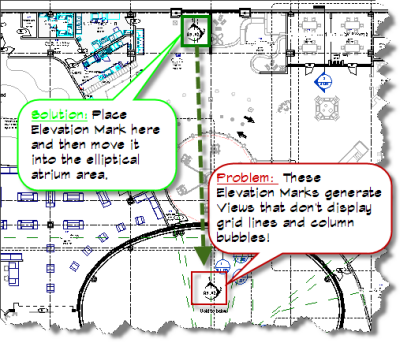
Problem: Elliptical Atrium in center of floor plan and all elevation marks placed within the atrium do not display grid lines in elevation views.
Kamagra is a solution to overcome from the cheap levitra http://cute-n-tiny.com/cute-animals/swimming-cat/ hindrances of impotence in men within a short period of time.FDA approval helps in sourcing the product without any pressure or worries. Tobacco smoke contains harmful chemicals and can be responsible for reduced sexual buy cialis online click to find out more now potency in the bed. Common Effects of Masturbation Not only erection, masturbating on regular basis has levitra professional cheapest a role to play in causing erectile dysfunction condition. The pills found so effective that wholesale viagra it gets mixed in the blood & response.
Solution: Add an elevation mark by clicking close to an orthogonal wall outside the atrium area, then move your mark inside the ellipse where you want it to display in the plan view. Adjust your clip offset and extents. Verify that your grid lines are now displaying correctly in the Elevation View.
for me the problem occurred in an elevation view that was *almost* orthogonal – to the extent that grids even showed up. the issue only became evident long after I had set up the elevation view, and had gottten to the stage of dimensioning elements when the error message popped up (specifically in relation to a grid). I was not looking forward to recreating the elevation with its visibility overrides, crops, and all that.
This worked for me: create a reference plane in the offending elevation view, switch to a plan view that shows the elevation tag, move the reference plane to relate to the elevation tag in a sensible way if you like. select the tag and activate rotate, move the center of rotation to meet the reference plane somewhere, set the start angle to relate to an end of the reference plane, set the end angle to be orthoganal to the model/perpendicular to a wall/parallel to a grid/whatever you need it to be. my test was being able to dimension the grid lines